Boundary County
Section 5
Hazard Profiles – Wildland / Urban Interface Fire
|
|
Definition, Description and Potential
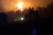
Damage Of the natural hazards that occur in Boundary County, forest
fires are the most frequently occurring events.
A high proportion of these fires occur in or near human habitations.
Forest fires occurring in the county have historically covered very large
areas of land. Under the right
conditions of fire-weather and dryness of forest fuels, a fire in the wild land
urban interface would have disastrous consequences.
The costs of fighting large wildland fires such as occur in Boundary
County are very high, and these costs go up exponentially when the fire is in or
near the Wildland Urban Interface (WUI). Potential
losses from an event that destroys many structures, and perhaps involves loss of
human life, are extremely high.
In 2003, Boundary County
contracted with Inland Forest Management, Inc. (IFM) for the completion of a Wildland/Urban
Interface Fire Mitigation Plan. This
plan included numerous considerations for wild land fire mitigation including
risk assessment, public involvement, appropriate strategies and priorities for
mitigation work. Only highlights
from the fire plan are included within this All
Hazards Mitigation Plan, however, the entire Wildland Fire Mitigation Plan
is considered incorporated by reference.
Brief Fire History
Large forest fires have played a prominent role in the forests of
Boundary County since the end of the last glacial period.
Most forest types in the county show a history of large stand-replacement
fires that often leave burn patterns of several thousand acres on the landscape.
Large fires have been caused both by lightening and humans.
Large fires have been documented
since 1900, many of which have occurred in present day wildland/urban interface.
In 1910, a large fire burned along the Katka face and into Montana.
The Hellroaring fire burned from Round Prairie to the top of Queen
Mountain in 1926. In 1931, the Deer
Creek fire started in Lower Deer Creek and burned north and east into the Yaak
River drainage in Canada.
Two large fires occurred in the
Selkirk Mountains, Sundance and Trapper Peak, in 1967.
These fires burned outside urban areas, but during its historic run, the
Sundance fire pelted the Kootenai River valley with firebrands.
It is perhaps only by good luck that this fire did not cause a disastrous
wildland/urban interface fire somewhere in the Kootenai Valley.
In the past 18 years, an average 23.4 wildfires per year have been fought on
USFS protection lands and 26 wildfires per year have been fought on IDL
protection lands. Some of the fires
on USFS protection and virtually all of the fires on IDL protection either had
the potential or actually posed a threat to the WUI. Under conditions conducive to high rates of spread, or long
distance spotting, IDL studies show that a fire can threaten individual and/or
groups of homes in the time between ignition and response by firefighters.
This brief summary of some of
the larger recent fires in the county and average fire occurrence in the county
shows why fire managers have had a long-standing concern for the protection of
life and property within the entire county.
Fire history, existing fuel types, and the expansion of dwellings further
into the wildland setting all suggest that there is a need to assess and address
the potential for future disastrous fires.
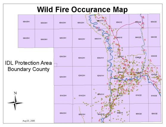
Map 5-1
WUI Mitigation Needs
The Boundary County Idaho Wildland/Urban Interface Fire Mitigation Plan
defined the type of work needed to reduce the potential for losses of life and
property from fires in the WUIF. The
goal of that plan is to create defensible space (safe area for fire fighters)
and survivable space (sufficient reduction in fire behavior to help the building
survive) around any building that is selected for fuel mitigation work.
To create defensible/survivable space, natural forest fuels are modified
to reduce the intensity of fire that would occur if they were to burn.
Fuel reduction is done at least 100 feet out from the perimeter of the
building (if property boundaries allow). Fuel
treatment involves the following general kinds of work activities:
1.
Removing most shrubs and conifer saplings and pole timber within 30 feet
of the building.
2.
Thinning conifer saplings to the perimeter boundary so that the crowns
are not touching and the trees have room to grow without again becoming
interlocking.
3.
Pruning all trees within the treatment area to one-half live crown or to
the point that remaining foliage is at least 10 feet off the ground.
4.
Pruning tall conifers within 15 feet of buildings to the point that no
foliage is below the eave line.
5.
Mowing most shrubs and brush to the perimeter boundary.
6.
Thinning trees whose crowns are in the main canopy so that the canopy is
not continuous and is incapable of sustaining a crown fire.
7.
Piling and burning, or chipping and spreading residues from the thinning,
mowing and pruning activities.
Priorities for Fuel Treatment The Boundary County Idaho Wildland/Urban Interface Fire
Mitigation Plan established priorities for fuel treatment work to reduce the
risk to loss of life and property in the event of wild land fires in the county.
As recommended in the plan, a fuel reduction program (called Fire Safe)
has been in place since 2003, with accomplishments in all of the categories
listed below.
Table
5-1. Priority Fuel Treatments by
Rank
|
Priority |
Description
|
|
#1 |
Demonstration Projects |
|
#2 |
Treat periphery and wild land inclusions of Bonners
Ferry. |
|
#3 |
Treat fuels around resident schools. |
|
#4 |
Treat fuels around rural homes rated High Risk
where owners are willing. (Includes residences in Naples and Moyie
Springs). |
|
#5 |
Treat fuels around homes rated as moderate risk if
and when funds are available. |