 |
 |
Boundary County
Section 6
Hazard Profiles - Landslides
Definition,
Description and Potential Damage
The Boundary County Hazard Identification and
Risk Analysis define a landslide as a mass movement of rock, earth or debris
down a slope. The steeper the
slope, the more likely a slide will occur.
However, this is dependent upon the geology and soils associated with a
particular site. Loose soils
perched on steep slopes with little or no vegetative cover are highly
susceptible to landslides. Human
activity can add to this problem by creating less stable situations. For example, highway construction can increase the potential
for landslides by restructuring the slope and the combination of materials.
Increasing development can increase runoff and saturate soils.
For a landslide to
occur there must be a trigger. The
most likely trigger for landslides is a combination of precipitation and human
activities. Inherent weaknesses in
the rock or soil often combine with one or more triggering events, such as heavy
rain, snowmelt, or changes in ground water level. Late spring to early summer is slide season, particularly
after days and weeks of greater than normal precipitation. It not only triggers slides
but also changes the shape of rock and earth as it runs off into streams.
Vegetation can help with the retention of runoff and serve as a barrier
to sliding. Fire damage can reduce
the potential for this vegetation to serve as a barrier to slides.
Much of the county is exposed to wildfires, which could increase the
potential for slides. In fact, many
slides occur as a result of some other natural hazard.
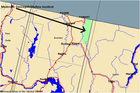
National
Atlas.gov and FEMA’s risk map (Map 6-1, pg. 6-3) indicate that the landslide
risk in Boundary County is low.
Landslide
History
The
Map of Historical Landslides (Map 6-2, pg. 6-4) from Boundary County’s
2001 risk assessment shows several types of landslides that occurred in the 20th
Century. Most of these occurred
adjacent to roads where erosion and steep slopes have combined to produce these
slides.
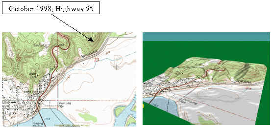
In
1998, a landslide closed US Highway 95 at the northern city limits of Bonners
Ferry. Highway 95 is the only route
into Canada and Montana from Boundary County.
As a result, this slide affected all traffic flow, both north- and
southbound, for several months.
Table
6-1, below, is a summary of significant landslide events that have occurred in
Boundary County within the last 50 years. As
there is no current data tracking system in place for detailed descriptions,
this list has been compiled using historical records.
Table
6-1. Significant Landslide Events
in Boundary County
|
DATE |
NOTES |
EFFECTS |
|
March 1954 |
In Bonners Ferry |
Two Fatalities, Highway 95 |
|
March 1959 |
Mud Slide |
Train Derailment |
|
February 1961 |
Mud Slide |
|
|
May 1961 |
Mud Slide |
Road Closures |
|
May 1965 |
Mud Slide |
Roads blocked, washed out |
|
March 1972 |
Mud Slide |
Covers House |
|
June 1974 |
Mud Slide |
45,000 cubic yards |
|
January 1981 |
Mud Slide |
Minor Damage |
|
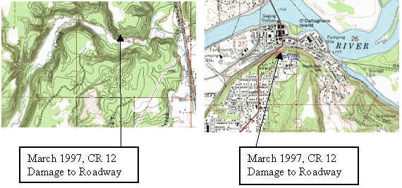
March 1997 |
Mud Slide |
Damage roads, injuries |
|
October 1998 |
Mud Slide |
Destroyed Highway 95, Railroad. School Closures |
Critical
Facility Exposure Assessment
Most of the property exposed to
danger from landslides lies along the major roadways in the county, with the
exception of communication repeaters. The major roadways have received attention
and monitoring regarding landslides. There has been no recent landslide that has
affected any critical facility, except the recent Highway 95 landslide in
Boundary County.
Summary Landslides
are a potential hazard and can cause disruptions by blocking roads, destroying
homes and other property. Boundary
County must insure that proper development standards are instituted to reduce
the potential for landslides due to development in the county, particularly on
steep slopes.
|
|
 |
|
|
PREVENTIVE MEASURES
1.
Develop subdivision design standards for steep slopes to reduce the
potential for landslide events during construction and post development.
Lead
Agency:
Local building and planning department
When:
Five to seven years
Resources/Funding: Local building and planning department operating budgets
2.
Require site design review of all development projects proposed on slopes
to insure stability, based on known information, evaluation of slope and soil
stability characteristics.
Lead
Agency:
Local building and planning departments
When:
On-going
Resources/Funding:
Local
operating budgets
3.
Identify and map key locations adjacent to existing roads that are highly
vulnerable to landslides.
Lead
Agency:
Boundary County GIS
Supporting
Agencies: Boundary County Road
and Bridge, Idaho Department of Transportation, National Resources Conservation
District, and US Forest Service
When:
Three to five years
Resources/Funding: County, state and highway district budgets
4.
Prohibit future construction of public critical facilities, businesses
with hazardous materials storage and private roads on slopes that may create a
hazard. Evaluate project sites on an individual basis to assess risk
due to soil stability characteristics and slope stability.
Lead
Agency:
Local building and planning departments
Supporting
Agencies: Local elected officials
When:
On-going
Resources/Funding:
Policy action, no funding needed
5.
Support programs that assist Boundary County Road and Bridge with
restoration of degraded slopes through re-vegetation and slope stabilization
efforts in landslide hazard areas adjacent to county road and bridges.
Lead
Agency:
Local Emergency Planning Committee
Supporting
Agencies: Boundary County
Office of Emergency Management, highway districts
When:
Two years
Resources/Funding:
Policy
action, no funding needed
6.
Have information at building and planning departments on spray barriers,
netting for rock slide prone slopes, and cement barriers available to
contractors to minimize landslide occurrences on private roads.
Who:
Local building and planning departments
When:
Two years
Resources/Funding: Educational materials from Federal Emergency Management Agency, American Planning Association, Soil Conservation District
7.
Support local, state and federal reforestation efforts on steep slopes
after wildfire to minimize mud and landslides.
Who:
Local Emergency Planning Committee
Supporting
Agencies: Boundary County
Office of Emergency Management, highway districts, Idaho Department of
Transportation, Idaho Department of Lands, US Forest Service, fire services,
National Resources Conservation Service and Soil Conservation District
When:
Two years
Resources/Funding:
Policy action, no funding needed
8.
Provide information to property owners on retrofits of buildings
constructed on soft soils in high risk landslide locations.
Lead
Agency:
Local building and planning departments
When:
Two years
Resources/Funding: Educational materials from Federal Emergency Management Agency, American Planning Association and Soil Conservation District
9.
Identify landing zones for emergency services in key landslide prone
areas to expedite emergency services.
Lead
Agencies:
Law enforcement agencies
Supporting
Agencies: Boundary County
Office of Emergency Management, fire services, emergency medical services,
highway districts, Idaho Department of Transportation, MedStar, emergency
responders.
When:
Three to five years
Resources/Funding: Agency operating budgets